Human Rights Group B’Tselem Creates Interactive Map of 52 Year Israeli Settlement Growth

by | Jun 5, 2019

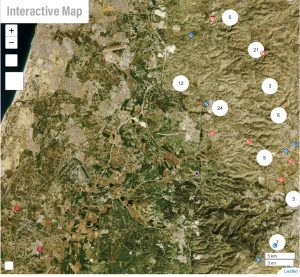
“This visualization of the occupation shows how a combination of measures – annexation; establishment of settlements; declaration of ‘state land,’ firing zones, nature reserves and national parks; construction of the Separation Barrier; division of the West Bank into Areas A, B and C with varying forms of control; and severing the Gaza Strip from the West Bank – has broken up Palestinian space into separate units that are easier to control in isolation,” B’Tselem said.

through the annexation efforts Palestinian communities are more isolated from one another and therefore are “easier to control” by the Israeli government.

About Steven Woskow

Steve Woskow is an entrepreneur and was President of Agtech Products, Inc., a research and development company specializing in animal agriculture. He has a Ph.D. in Nutrition and Food Science from Iowa State University. He is retired and lives with his family in Northern Nevada.

Our Books

latest book lineup.

Related Articles

Related

The Eternal Panopticon: The State as Predator

Lizard Farmer did an excellent synopsis of how the state stalks its prey. The observations are older but still germane. If London had this technology in 1770, America would not have been born and Paul Revere, the Committees of Correspondence and his colleagues would...

read more